
Managing the Old River Control Structure for fish and crawfish populations
LCPA-West and ABK have been requesting for over one year that the Corps change the way they manage the Old River Control Structures (ORCS) to better help fish crawfish populations in the Basin, benefiting, not only our beloved fishermen, but also all the wildlife that depends on crawfish and fish to survive. On April 8th and 9th the Corps put together meetings with landowners, scientists and agencies to create guidelines for better management of the ORCS and our recommendations were accepted. We should see if this results in better days for everyone, humans and animals, in the Atchafalaya Basin. We want to thank General Peeples and Colonel Jones for their continue engagement with us.
You can read these recommendations here.
Atchafalaya Basin Management Plan for Flood Protection, Ecological Enhancement, Wetland Protection, and Coastal Restoration
Introduction
Floodplains are critical for flood protection, even more so in southern Louisiana than in most places in the country. Good water management and floodplain protection is crucial for future generations to live safely in southern Louisiana, and to enjoy the same natural world that we enjoy today. Ultimately, we are borrowing these natural resources from the generations to come.
When floodplains disappear, their ability to absorb floodwaters is lost. Whether filling in the floodplains of the Atchafalaya Basin to create uplands, or building a levee to isolate the Basin, the effect is the same. The way that the Atchafalaya Basin (and the rest of coastal Louisiana) is being managed is unsustainable. As a result, we are destroying an irreplaceable ecosystem, and with it, ecosystem services that are integral to preventing flood disasters today and in the future.
When Our Levees Work Against Us
The Atchafalaya Basin Spillway (or simply the Spillway) illustrates how levees can intensify flooding in surrounding areas. The Spillway was designed by the Corps of Engineers to protect people and property from the flooding of the Mississippi River.
The ability of the Atchafalaya Spillway to absorb floods is immense. During the great flood of August 2016, Grand River at Bayou Sorrel crested at 10.39 ft. on August 17, but the Spillway across the levee at the Bayou Sorrel Locks crested three days earlier, August 14, at only 7.1 ft. Ongoing research conducted by Atchafalaya Basinkeeper on a property in the Iberville Parish community of Bayou Sorrel, recorded that during that flood the yard at the site of research was about 1.39 feet under water and the elevated house was about 1.6 feet above water. Without the levees that yard would have been about 1.5 feet above water. This is an instance where levees created a flood rather than preventing one.
In contrast, in 2011 the water stage inside the Spillway at Bayou Sorrel crested at 17.4 ft; without the levees that same house would have been more than 5 feet under water. Levees are built for flood protection; however, they can also be responsible for transforming our towns and cities into floodplains by preventing drainage into rivers and other natural waterways.
The Atchafalaya “Spillway” Today
The Atchafalaya Basin Spillway is incredibly important for Louisiana, the nation, and the ecology of our planet. It contains the largest river swamp in North America. Producing the single largest wild harvest of crawfish in the world, the Atchafalaya Basin’s swamps are considered to be the most productive wetlands on Earth. It is the last bastion of our Cajun culture. Situated at the doorway of the Mississippi Flyway, the Atchafalaya Basin is arguably the single most important ecosystem for migratory birds in the Western Hemisphere. It is a critical habitat for a rich and diverse variety of wildlife, including threatened and endangered species. In a land of vanishing wetlands and sinking coast, the Atchafalaya Basin provides the only growing delta in the state.
As important as the Atchafalaya Basin is for ecological values, we must not forget that the Basin is also a spillway that is critical for flood control. As the Basin's swamps, lakes and bayous become uplands, the flooding capacity of the Basin is being compromised. Since 1932, there has been a net accretion of nearly 2.5 billion cubic meters of sediment in the Basin floodway, converting a substantial amount of open water and cypress swamps to bottomland hardwood forests. This greatly reduces the ability of the Spillway to handle floodwaters.
With responsible management, we could increase the ability of the Basin to handle floods inside and outside of the levees, build more land along the coast, and improve water quality and seafood production.
A Holistic Management Plan for the Atchafalaya Basin Spillway
Holistic, sustainable management of the Atchafalaya Basin should have three components:
Hydrology should be restored, as near as possible, to its original state (before levees were built) to allow the Spillway to capture floodwaters from both sides of the levees, thereby protecting communities from river flooding, as well as flooding from local rains. This would improve water quality, wildlife habitat, and ultimately seafood production.
Sediments should be managed and contained in the main river channel, away from swamps, lakes and bayous, to maintain the floodplain’s ability to handle floodwaters, protect critical wetland habitat, and rebuild our coast.
The management design should be done in such a way as to preserve the ecosystem, thus maximizing natural ecosystem services such as sustainable flood protection.
Pumps Versus Channels and Locks
Water pumps do not provide any significant ecological benefits to the Atchafalaya Basin and the communities who depend on the Basin’s resources. Fish and shellfish cannot freely navigate through the pumps. Pumps can also be very expensive to operate and maintain.
In contrast, building channels with gates to reconnect waterways could have extensive ecological benefits. These channels would allow fish and shellfish to migrate throughout the Basin, expanding the productivity of the entire Basin to the rest of coastal Louisiana. Channels and locks also allow natural systems to operate, exchanging nutrients and improving water quality. People could again navigate by boat into and out of the Atchafalaya Basin for fishing and recreation, which could ultimately promote ecotourism. Those gated channels are way more efficient for flood protection than pumps, since they can move significantly more water across the levee during local floods with low river water levels.
Water pumps could be strategically installed in addition to the channels, to provide additional protection, in the event of a flood during our annual high-water season.
Here, by aerial photographs and added text, is an explanation of how the Atchafalaya Basin could be restored in a way that would protect South Louisiana from future flooding. This restoration plan would also protect the Basin from further destruction, as well as increase its productivity and environmental health.
Restoration of Hydrology for Flood Protection and Ecological Enhancement

Grand River to Grand River Connection and Pump

Lock should be kept open at low river stages; and should be closed for flood protection and sediment management during high river stages. Pump to be used for drainage during high water season. Coordinates: 30°13’26.10”N 91°25’13.46”W
Bayou Sorrel Pump

To be used during high water season for drainage. Coordinates: 30°08’23.09”N 91°19’35.69”W
Bayou Pigeon-Grand River Connection, Lock and Pump

To be left open; closed only during high river stages. Pump to be used during high water season. Coordinates: 30°05’08.09”N 91°18’24.35W
Old River-Belle River Connection, Lock and Pump

To be left open; closed only during high river stages. Pump to be used during high water season for drainage. Coordinates: 29°56’26.80”N 91°15’22.16”W
Flat Lake-Lake Palourde Connection and Lock

To be left open; closed only during high river stages. Coordinates: 29°44’08.00N 91°10;34.92”W
Lake Dauterive Connection, Lock and Pump

To be left open; closed only during high river stages. Pump to be used during high water. Coordinates: 30°04’30.26”N 91°37’19.94W
Pump and Siphon by Henderson Locks

Siphon and pump to be used during low water season. Pumps only to be used during high water season. Coordinates: 30°14’58.83”N 91°43’32.51”W
Henderson Lake connection and lock

To be left open until needed for flood control. Coordinates: 30°18’19.62”N 91°44’52.48”W
CONCEPTUAL FLUVIAL SEDIMENT TRAPS, A SUSTAINABLE MANAGEMENT TOOL FOR THE ATCHAFALAYA BASIN.
Ivor Ll. van Heerden, PhD.
Former Professor, LSU Department of Civil and Environmental Engineering.
Introduction:
The Atchafalaya Basin Floodway is a major component of Mississippi River flood protection, as envisaged by the Mississippi Rivers and Tributaries Project (M R & T). For a large section of Louisiana – a real public safety necessity. The Lower Atchafalaya Basin Floodway System project has two mutually supporting goals: to preserve the habitat of the nation’s largest and oldest river-basin swamp and to ensure that the Lower Atchafalaya Basin can pass a floodwater of 1.5 million cubic feet per second as required by the M R & T. The 833,000-acre Lower Atchafalaya Basin Floodway is bounded on the north by U.S. 190, on the east and west by the Atchafalaya Basin protection levees, and extends south to the Gulf of Mexico (Figure 1). (https://www.mvn.usace.army.mil/About/Projects/AtchFldySys/#:~:text=The%20833%2C000%2Dacre%20Lower%20Atchafalaya,to%20the%20Gulf%20of%20Mexico).
As reported by the Louisiana Department of Natural Resources in 2013, who quoted a 2001 U S Geological Fact Sheet, from 1932 until 2001 there had been a net accretion of nearly 2.5 billion cubic meters of sediment in the Basin Floodway, converting much open water and cypress swamps to bottomland forest (DRAFT FY 2013 Annual Plan Atchafalaya Basin Program – LDNR). That is 3.25 billion cubic yards. In the 24 years since 2001, just how much more sediment has been deposited in the Basin? Using the 1932 to 2001 average rate from the USGS Fact Sheet could mean at least an additional 1.13 billion cubic yards could have been deposited for a total of at least 4.4 billion cubic yards since 1932.

Figure 1. Atchafalaya Basin Floodway
SO, THE ATCHAFALAYA BASIN FLOODWAY AS ENVISAGED IN THE ORIGINAL M R & T PLAN HAS LOST 101 BILLION CUBIC FEET OF FLOOD STORAGE CAPACITY. It is losing its Public Safety benefits; as presently managed its flood control function diminishes every day.
What is a Fluvial Sediment Trap:
Sediment traps detain sediments in stormwater or river runoff to protect receiving streams, lakes, wetlands, drainage systems, and the surrounding area. The traps are formed by excavating a depression or by placing an earthen embankment across a low area or drainage swale. The sediment trapped may be left in place or recycled elsewhere, in others words it can be mined or physically moved from the area of concern.
Components of a Conceptual Sediment Trap as envisaged for the Atchafalaya Basin:
Sediment traps are proposed in various locations down the main channel of the Atchafalaya River. The latter has extremely high suspended sediment loads especially in floods. These waters exit the main river channel, with their high sediment loads, as they flow down mostly human-made or human manipulated branch channels that direct these suspended loads miles into the interior swamps and lakes of the Atchafalaya Basin (Figure 2). Once these sediment flows pass from the constricted branch channel into open areas of the Basin, they go from a ‘confined’ regime to an open water still environment; the water flow loses energy, and the suspended sediments are rapidly deposited. One such flood event can deposit in excess of 3 feet of sediment per season. Figure 2 is a LiDAR Image of a section of the basin that dramatically presents the reality of the suspended sediments entering the interior locations of swamps. The bright colors indicate sediments that have moved down mostly human-made channels to interior and beyond portions of the Basin. The ongoing process of infilling and choking the Basin is dramatically revealed by the interfingering channels and sloughs that are strongly depicted (Figure 2). The dire consequences of this sediment infilling of the Basin will be discussed in greater detail below.
In order to attempt to intercept and capture most of the suspended sediments, a trap needs to be excavated or dredged just downstream of the branch channel’s connection with the River (Figure 3). The trap excavation needs to be significantly wider and deeper than the branch channel and be a few hundred feet in length. Why these dimensions? Well, the confined flow coming from the River has to enter a wide cross-sectional area in order for it to go through the velocity drop transformation in passing from a narrow-confined channel to a wide-unconfined location. The subsequent loss of velocity, really inertia, causes up to 90% of the suspended sediment to drop out of flow and be deposited (Figure 3). Then the relatively sediment-poor flow continues past the trap and down the remaining length of the branch channel until it reaches interior locations of the Basin. The result is a significant reduction in sediment deposited in the interior swamps with reduced negative consequences.
Now, obviously a sediment trap so excavated, if left alone, will after some period no longer function as a trap as it has reached a sediment-filled state! Imagine a small dredger entering the trap from the river and dredging the trap back to its original dimensions with the sediment then passing down a floating, partially flexible discharge pipe and being sprayed out the end with a fantail spreading the pumped material back into the river downstream (Figure 4).

Figure 2. Section of LiDAR imagery of the Atchafalaya Basin. This image via the brighter reds and yellows indicates sediments that have been recently deposited in this section of the Basin in the last 20 or so years. North is to the left.
An important aspect of sediment trap utilization is to reconnect the original bayous or channels. These, such as the original natural Grand Bayou were relatively narrow and sinuous, not the highly efficient sediment transport conduits subsequently excavated by the Corps of Engineers.

Figure 3. Schematic of a conceptual sediment trap that could be built at various locations in the Atchafalaya Basin to reduce sediment infilling interior swamps, lakes and water bodies.

Figure 4. Schematic of ‘cleaning out’ a sediment trap with a cutter suction dredger attached to a long flexible floating exit pipe to dump the sediment dredged from the trap downriver.
Enter a cutter/suction dredger with a long floating pipe heading down the branch channel; pipe long enough to stretch a few hundred feet downstream the River from the entrance to the branch channel and releasing the dredged material from the trap back into the River (Figure 4). In essence recycling the sediment which conceivably will be usable down at the coast for natural and/or restoration project beneficial use – helping to protect the coastline.
In this way everyone is a winner.
Dredging to maintain the Bayou Sorrel Lock – an example of a sediment trap!
As of mid-2024 the Corps of Engineers has on 26 occasions had to dredge open the Bayou Sorrel channel downstream of the lock to ensure boat traffic safety. If you note in Figure 5 the Location marked A is a narrow-confined channel being Bayou Sorrel. Now compare A to the channel at location B and it is very evident that B is much wider than A. So as suspended sediment laden waters move down the channel from A to B they go from the confined channel to an unconfined channel and as a result the flow slows down, loses inertia, and significant amounts of suspended sediment are deposited. In fact, over 9 million cubic yards of sediment have had to be dredged from the ‘sediment trap’ portion of the channel. This sediment, instead of being recycled, has been piled in high spoil piles and at least 1000 acres of swamp have been destroyed (See Figure 6; marked as C)! This example, which is really a headache for the Corps of Engineers, proves that sediment traps with sediment recycling in the Atchafalaya Basin are very feasible and need to be part of the solution.
Need to keep Basin free, to the extent possible, of sediments!
The Atchafalaya Floodway is an integral part of the Mississippi River and Tributaries Project (M R & T) to save Louisiana south of the Old River Control structure from the next massive Mississippi River flood such as occurred in 1927. This includes New Orleans. The M R & T plan was formulated in the early 1950’s and basically has not changed since. A very important component of the flood relief plan is to use the Atchafalaya Basin as a huge ‘bathtub’ to hold flood waters to protect all surrounding communities.
The Plan formulated in the 1950’s has no consideration of climate change over time or sea level rise or as we are now experiencing, storms on steroids (Hurricane Helene in 2024 comes to mind). It also has no consideration for the fact that the Atchafalaya Basin has much less volume to hold flood waters today as compared to say in 1950 because of the millions of tons of sediment that have been deposited in the Basin. As reported by the Louisiana Department of Natural Resources in 2013 using information from a U S Geological Survey Fact sheet of 2001, since 1932 there had been a net accretion of nearly 2.5 billion cubic meters of sediment in the Basin floodway, converting much open water and cypress swamps to bottomland forest (DRAFT FY 2013 Annual Plan Atchafalaya Basin Program – LDNR). That is 3.25 billion cubic yards. In the 24 years since 2001, just how much more sediment has been deposited in the Basin? Using the 1932 to 2001 rate could mean at least an additional 1.13 billion cubic yards could have been deposited for a total in excess of 4.38 billion cubic yards since 1932.

Figure 5. Bayou Sorrel Locks

Figure 6. LiDAR Image of Bayou Sorrel locks dredge material/spoil piles marked as C. More than 9 million cubic yards!
SO, THE ATCHAFALAYA BASIN FLOODWAY AS ENVISAGED IN THE ORIGINAL M R & T PROJECT HAS LOST 101 BILLION CUBIC FEET OF FLOOD STORAGE CAPACITY!
This loss of capacity was not considered when the M R & T Project was first formulated in the early 1950’s. It places in question if the Floodway could hold another 1927 flood and stresses the urgency to minimize the amount of sediment getting into the Basic henceforth.
Conclusion
The Basin cannot hold all the waters it was designed to do in the original 1950’s M R & T plan. Any project that increases sedimentation in the Basin threatens public safety from major floods. This is a very real reason to incorporate sediment traps in the overall management of the Basin.
Lastly, sediment is needed at the coast if we are ever going to feel safe from major hurricanes, we need to repair, restore and build up our coastline to the full extent possible. For that there is one real solution, use the sediment resources of the Mississippi River! Sediment traps allow recycling of sediment originally deposited in the Basin to flow down to the coast where it is sorely needed.
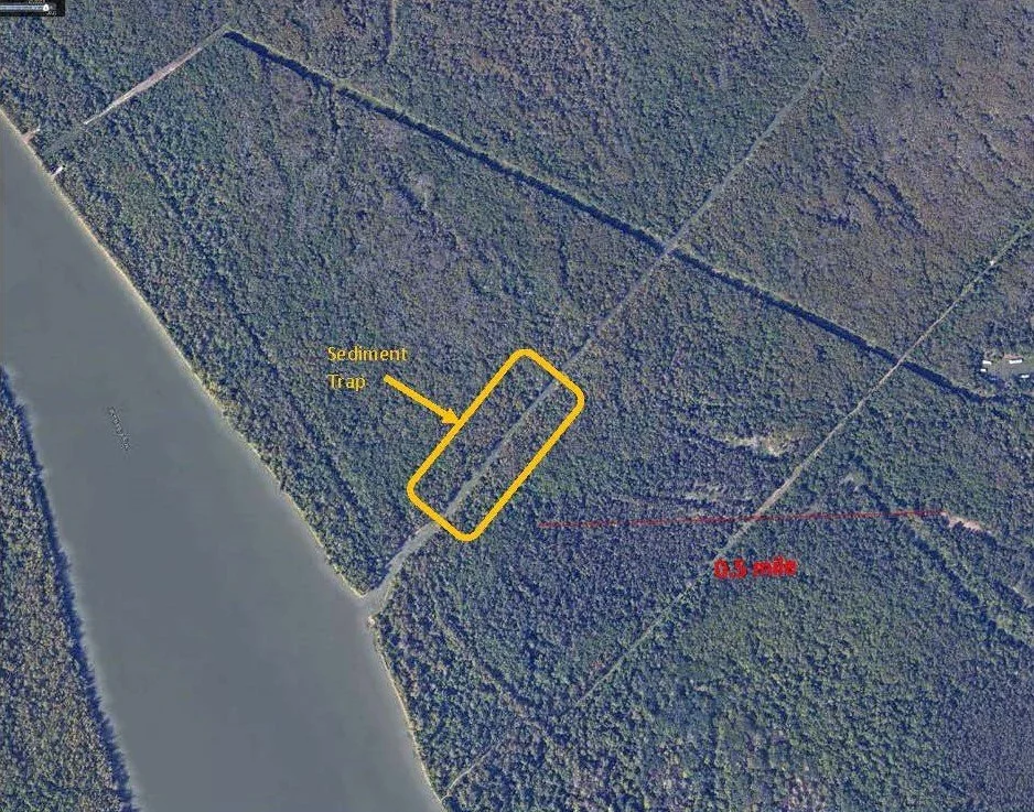
Whiskey Bay/Atchafalaya River Sediment Trap
To keep bedload in the main channel away from the Basin's swamps, lakes and bayous. Sediment trap to capture and dispose of sand back in the channel. Coordinates: 30°23’17.18”N 91°40’46.39”W
Closure of Grand River to be Replaced by Reopening Tensas
The realignment of Grand River in 1994 greatly increased sand and sediments in wetlands with significant negative effects to the hydrology of the floodplain, and ecological services. Sediment trap to be managed by disposing of sand in the channel.

Closure Grand River Cut coordinates: 30°14’05.93”N 91°33’25.97”W
Reopening Tensas coordinates: 30°12’21.90”N 91°32’07.09”W
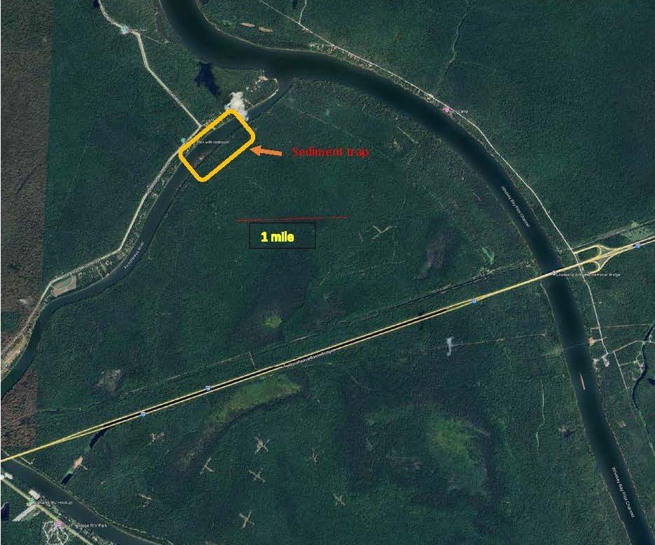
Bayou Sorrel Restoration. Bayou Sorrel Cut Closure, Restoring Jakes Bayou, Sediment Guide Weir and Sediment Trap.
The realignment and straightening of Bayou Sorrel and the closure of Jakes Bayou around 1969-1970 increased bedload and sediments moving into Bayou Sorrel with significant negative effects to the hydrology of the floodplain, and ecological services. This needs to be reversed. Sand should be guided to stay in the main channel of the river, and sand from the river into the bayou should thereby be reduced. Sediment trap should be managed by depositing sand back in channel.

Bayou Sorrel Cut closure: 30°06’53.29”N 91°28’36.34”W
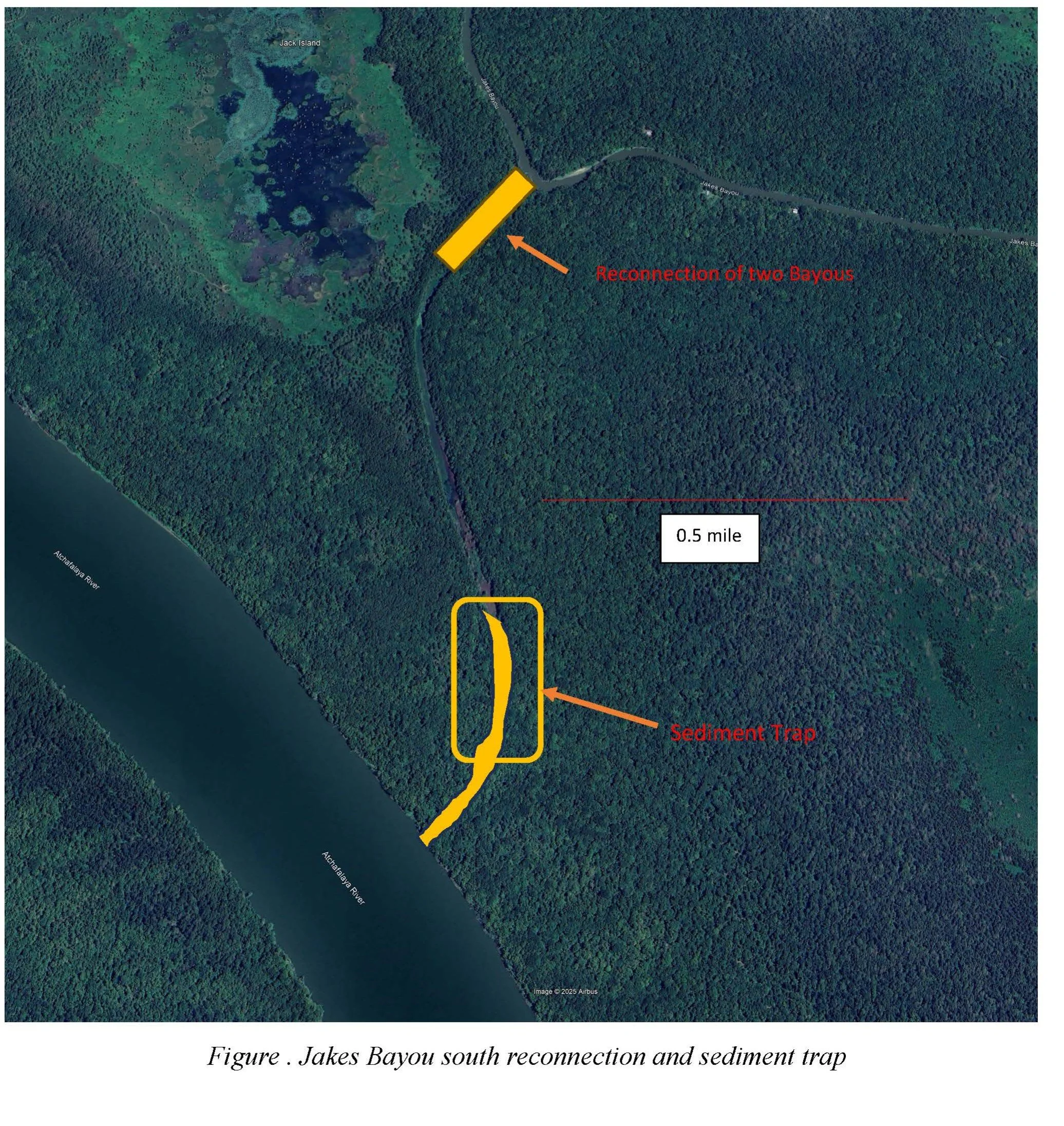
Restoring Jakes Bayou, sediment trap Coordinates:
30°08’08.81”N 91°29’52.10”W

Sediment Trap Jakes Bayou North coordinates: 30°10’38.97”N 91°31’17.68”W
Bayou Chene Restoration. Bayou Chene Cut Closure, Restoring Old Bayou Chene and Sediment Trap.
Bayou Chene was dammed around 1989, and flows from the river were diverted through a new straight cut at the end of a river bend. This increased sand distribution and sediments into the bayou with significant negative effects to the hydrology of the floodplain and ecological services. Sediment trap should be managed by depositing sand back in the channel.

Bayou Chene Cut Closure: 30°09’17.11”N 91°31’31.87”W

Reopening Bayou Chene Coordinates: 30°07’30.03”N 91°29’54.40”W
Blue Point Chute Sediment Trap
Sediments moving down Blue Point Chute have resulted in the rapid filling of open water and swamps. Sand should be guided to remain in the main Atchafalaya River channel. Sediment trap should be managed by depositing sand back in the channel.

Blue Point Chute sediment trap coordinates: 29°49’29.73”N 91°22’26.61”W
Canal Into Bayou Boutte Sediment Trap
This canal brings vast quantities of sand and silt to Bayou Boutte and the Duck Lake area. Energy XXI made a major investment to restore Bayou Boutte; however, the effects of this restoration were temporary, and the bayou is again accumulating detrimental levels of silt.
Canal to Bayou Boutte sediment trap coordinates: 29°47’14.57”N 91°21.16.70”W
American Pass Sediment Protection Weirs 1 & 2. Sediment Traps
Sediments from the Atchafalaya River are seriously affecting American Pass and the Flat Lake area. Sediment traps should be managed by depositing sand back in the channel.

American Pass sediment trap 1 north coordinates: 29°45’53.72”N 91°15’07.42”W
American Pass sediment trap 2 south coordinates: 29°45’44.23”N 91°14’26.72”W
Sand/Sediment Mining for Unlimited Material for Coastal Restoration
We are proposing to build a sediment transport pipeline from Lower Grand Lake/Six Mile Lake to Flat Lake and Lake Palourde with 4 intakes, 2 east and west of the Atchafalaya River, one in Flat Lake and one in Lake Palourde. Sand and silt to be mined from the beds of Grand Lake, Flat Lake and Lake Palourde, to strategic spots on the coast and suction dredge what used to be the bed on Grand Lake, Flat Lake and Lake Palourde to its original depths, transporting the sand and silt through Terrebonne Parish toward the coast to be used to restore vanishing communities and restore the coast. As Grand Lake is being restored, the bed of Grand Lake will become a huge sediment trap where sand and silt can be mined forever, year after year. Enough sediment will be going through to keep the Atchafalaya Delta healthy and it will be a huge help for the Port of Morgan City and navigation by limiting or eliminating the need for dredging to keep the port open all year round.

Pipeline intake 1 coordinates: 29°44’43.51”N 91°15’08.37”W
Pipeline intake 2 coordinates: 29°44’46.11”N 91°13’24.91”W
Pipeline intake 3 Flat Lake coordinates: 29°45’02.85”N 91°12’05.74”W
Pipeline intake 4 Lake Palourde coordinates: 29°43”22.57”N 91°08’17.17”W


End pipeline coordinates: 29°20’58.91”N 90°34’06.65”W
Conclusion
We have something that no one else has, and that can never be re-created. Once it is gone, it is gone forever. The Atchafalaya Basin is of critical importance to the ecosystem and wildlife of the entire Western Hemisphere; and because of its beauty, ecological values, and ecosystem services including as a sediment source to restore the coast and flood protection, it is a vital asset for future generations here in Louisiana and humanity as a whole.
Resolutions of Support: